
Showing posts with label rivers of the world. Show all posts
Showing posts with label rivers of the world. Show all posts
Friday, October 29, 2010
River features intro
Today we started early to avoid the Halloween-y afternoon mayhem. We gave the kids time to add final details to their projects, which fortunately allowed some kids who had been absent to catch up. When everyone was finished I called 3 sets of students 2 at a time to take a look at some of their choices and ask the class what was the same and what was different. This was to reinforce the compare/contrast idea we introduced on Wednesday as well as to give the kids a chance to conclude the project with a critique of sorts. I also asked the kids what they thought the final product should be: a mounted piece to hang on the wall or a functional piece that would be useful. It was a unanimous decision to have something useful, so I'll be sewing them on the machine to turn them into little ditty bags which they can hold their upcoming timeline book project in.
 It was then time to introduce more river information. Cindy led the students in reading a packet that described rivers in their multiple aspects. Doing the reading helped emphasize main idea and details which we'll continue to stress when we start our river models next week. Cindy had begun a drawing on the board when the reading discussed ports at the mouths of rivers. When the reading began describing source and waterfalls, I continued the drawing so we ended with a full illustration on the board. With this in mind next week we'll have the kids sketch and plan what to include in their river models before we work them in clay.
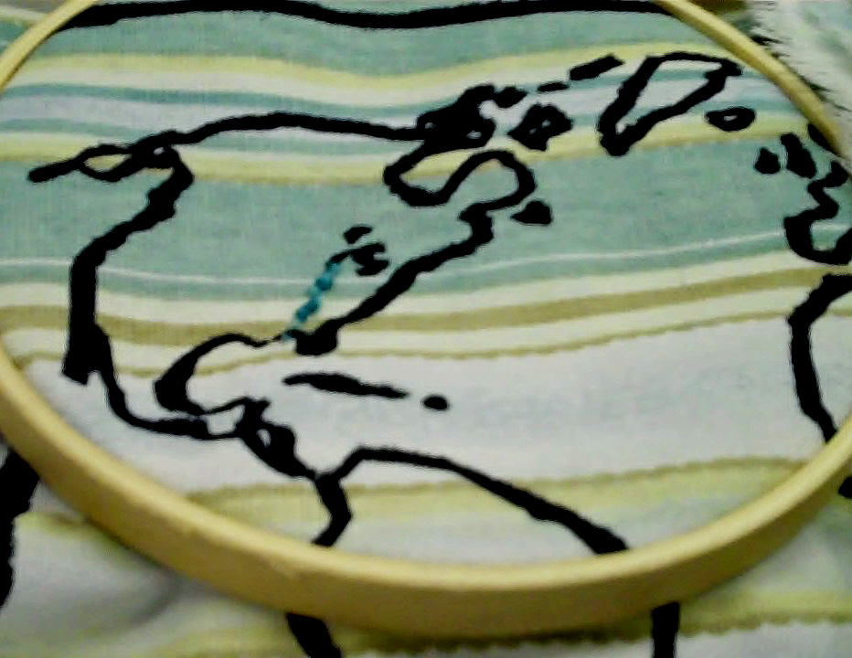
Day 12, finishing up Rivers of the World

On Wednesday when I came in, Cindy was having the kids review the "6-pack" for the Amazon river to transform the important points into sentence form. We hadn't done our 6-packs (the people, houses, plants, animals, problems, and uses) for the Nile, Volga, and Yangtze the other day in hopes to get lots of stitching done. So after they had completed the Amazon facts, we picture-walked through a book on the Nile River, with Cindy reading out loud, the students taking notes to add to a new 6-pack, and me writing down main points on a large sheet of paper to mirror the Amazon one they'd completed. This set us up perfectly for a Venn diagram organizer for a compare/contrast writing. I believe this was the first time they'd been introduced to the compare/contrast format and concept. With diagram handouts in the kids hands and a larger Venn diagram poster on the board I elicited what was the same about the Nile and Amazon to put in the overlapping section, and then what was special and different for each of the rivers to put in the left and right sides of the diagram. The children naturally made comparison statements like "The Nile is longer than the Amazon", and I pointed out that we use sentences like that a lot when making comparisons, especially using words such as less/more and -er endings. It would be great to continue this idea with some images, and perhaps we can spend a few moments tomorrow on comparing their maps to reinforce the idea of compare/contrast. Images are great for this kind of activity, and compare/contrast is an essential form for writing about art and aesthetics. With the Venn diagrams complete, Cindy collected them for use in their next writing assignment.

We brought up the overhead transparency of our Rivers of the World map to review which rivers have been studied and stitched so far (Mississippi, Amazon, Nile, Volga, and Yangtze), we counted out how many that was (5) and compared that to how many continents there are (7). I asked them which continent we hadn't done yet (Australia) and also asked why we weren't going to stitch any rivers in Antarctica (nobody lives there and it's too cold there for rivers to flow). We passed out the Atlases and had them find Australia and its major river (the Murray-Darling). I compared it to the Amazon river because both have their sources up in the mountains, and I compared it to the Nile river because both start as 2 separate rivers that join and have one mouth. We discovered a new word for a body of water-- the Murray-Darling's mouth is in the Great Australian Bight (a shallow, curved bay). As always I asked them to find the source of the river as their starting point for stitching and the mouth as the end point for stitching the river. I'm hoping this process of starting and ending in stitching will reinforce the idea of the beginning and end of the river and direction a river flows.


 Students quickly finished their stitching and as we had plenty of time, I brought out my fabric markers. I told them this was their chance to make their map their own and unique. I mentioned some options such as coloring in the continents like the map on the classroom wall, labeling the continents and the rivers, adding details to each continent and river based on the information they had learned from our six-pack exercises, etc. The children were VERY enthusiastic about coloring these in and were quite inventive in the details they added. Some added compass rose and cardinal directions, some created a color-coded map key, some wanted to add the equator, some drew animals and fish in the land and water. They had a clear idea about what should be on a map!
Now my challenge is making a final decision about how to make these more "finished" pieces in terms of the edges. I could either mount them on boards and tape the edges at the back, or I could be more labor intensive and add a backing fabric and seam the edges........

Saturday, October 23, 2010
Rivers of the World: Asia, Europe, and Africa
Today was a big catchup day. We decided to just do embroidery of the various rivers instead of doing an individual book exercise, then stitching. We reviewed the names of the continents and rivers we've learned so far. We had the kids work with the atlas, which they seem to be getting more familiar with. First we found Africa, and the kids quickly located the Nile. We noted the source in Uganda, that it travels through 3 countries, is the longest river in the world, and that the mouth is in the Mediterranean Sea. I had pre-threaded the needles today to help us get started faster. I was able to show them a new stitch- Whipped running, and several students used it.
We moved our hoops over to look at the continents of Asia and Europe. We sang the continents song again. We located the Volga River which sort of helps divide the continents of Europe and Asia. After they stitched the Volga we traveled across Asia to find one of the major rivers in China. We noted the location of the Yangtze, its source, and its mouth at the Sea of China. Some students were able to finish stitching the Yangtze, but others have not yet. It was time to get cleaned up and ready for the bus.
After today, to complete the project we only need to have the Yangtze and a river in Australia stitched. To review the Houses, People, Plants, Animals, etc. Cindy and I discussed just focusing on the Amazon and the Mississippi, and having the kids create a Venn diagram in their sketchbooks to compare and contrast. Some additional details can be added to their maps based on the information gathered. We're concerned with the kids' reading progress and need to find more ways to work in the literacy goals. As we'll be moving on to our river model, I recalled seeing a grade-appropriate description of river features in Cindy's collection of materials during our planning sessions we can use next week.
Wednesday, October 20, 2010
Amazon River
Today we were back in the classroom. It was a little weird having all those trips to skip back to our previous subject matter. Our goal was to cover the Amazon river of South America in our Rivers of the World exploration. We started off looking at the atlas to locate South America and its rivers. The students quickly found the Amazon. I asked them to find the equator, which was also a little blue line, but didn't meander. We also pointed out the equator on the globe to show how it went all the way around the world. I explained how it was always hot near the equator and Cindy reminded the students of previous discussions about climate and seasons.
We then gathered the students and I read a book on "Rainforests", highlighting the Amazon region. Reading the book brought up many of the people, plants, animals, problems, and uses of the Amazon River. Cindy created a word splash for our vocabulary as I read and we explained. Cindy then did a picture walk on 2 books about the Amazon specifically as the students took notes on the people, houses, plants, animals, problems, and uses. I don't know if it was because of the content presented or because the kids were more familiar with the note-taking process, but our chart for the Amazon seems much more full than the one for the Mississippi. Throughout the lesson Cindy and I made comparisons between what we were introducing to what the students had already learned in class and on the fieldtrips.
To complete our Amazon lesson we passed out the students' world map embroideries. I reminded them of how to move the hoop and reviewed the tool vocabulary. I traced the path of the river on the overhead transparency and reviewed source and mouth vocabulary. We quickly passed out the materials and helped the students thread and knot to be ready to stitch.
Once again we went overtime, and the art portion was very rushed. I'm wondering how it might work to do the atlas portion, then stitch the river, then do the book activities and chart. I wanted the students to add imagery based on the 6 chart points for rivers, but there hasn't been time. Perhaps as a culminating activity instead, students can work on the continent/river they found most interesting to add detail to the map when we're finished stitching. Cindy noted that last year I had the students do a practice/free embroidery before they worked on their final projects. I didn't do it this time because of how pressed for time we are. I think the stitching was better on the first day. They really need another review of technique.
Today was a bit difficult because the kids had a half day and there was a lot of nervous energy and noise. Hopefully on Friday we'll be more on task.
Wednesday, October 13, 2010
Wednesday, October 6, 2010
Rivers of the World/North America
There was so much to squeeze in today!!!!! We started off with the science and social studies pre-tests. Based on watching them work, they seemed to have a better handle on the vocabulary for science and social studies than they did for the art pretest. I have to mark them and see.
Once the pretest was finished I reviewed the continents we had learned last time. No hesitations, nobody told me states or country or city names, just rattled off the continent names! I asked them what continent we live on (response: North America). Then I asked if they knew what countries were in North America. This was a little harder. They seem to be unclear about the difference between a city, a state, a country, and a continent. These boundaries are so abstract. But finally we got the right response (United States of America, Canada, Mexico).
Cindy and I tag-teamed today. I was a bit unclear about how we were going to use the book resources to step through the people/animals/uses/problems, etc. Cindy led the rivers word splash brainstorm to see what the kids could come up with- and they did successfully generate all the topics we had hoped they would. They got a little carried away with ocean life and really wanted to show off their newfound geology science knowledge, so Cindy reined it in a little.
Then I read a short book titled "Living Near a River" by A. Fowler. This book generated a lot of new vocabulary for the kids, and each page sparked a short related description as Cindy and I bounced ideas back and forth
Cindy then took over leading the kids through a river find in their atlases. There were opportunities to use some of our arts elements vocabulary about lines..thin...curved...colors, as they tried to find things on the map. Then Cindy did a picture walk through a book about the Mississippi river and the kids listened and observed for information regarding people, animals, plants, houses, uses, and problems to write notes for the post-it page of categories. We lacked time today, but I'd like the kids to use some of that information to add imagery to their world maps.
People and animals were the most popular note-taking topics. Obviously those are areas that interest this age group a great deal.
There was very little time left, but my ultimate goal for the day was to get the kids to start stitching their world maps. I had them look at their paper version first to find North America, locate the Great Lakes and the Gulf of Mexico, and trace the path of the river between the 2. Then I asked them to find the same points on their fabric version. Cindy kindly printed out a transparency for me to project, and I marked and stressed vocabulary source, meander, and mouth. I passed around an example of my own embroidery for them to see and feel what the stitches should look like.
We quickly handed out supplies and I instructed the kids how to mount their fabric in the embroidery hoop. I'm calling our needle magnets a "dock" this time instead of a parking spot. And we compared the needle to a boat traveling down the river from the source to the mouth. I showed how to thread the needle and knot the ends and how to do a running stitch following the path they'd drawn.
I'm amazed at how quickly and smoothly the stitching went! Perhaps because Cindy has done this with me before she felt more comfortable helping the kids get started- threading and knotting, checking that they'd done it correctly. Perhaps it seemed to go so well just because we were stitching a short line. But I only saw one kid stitch around the hoop, and everybody had nice small stitches (I had stressed tiny,tiny stitches, too)
I feel very confident about stitching with these kids. Now that I've seen Cindy go through the Mississippi lesson I feel better about being able to lead our other world river lessons. If we'd had enough time today, I would have liked the kids to add images to their world maps with fabric markers or more stitching to show what they understand about the people/animals/uses etc.
I had the flipcam with me, but it's so hard to remember to document when you're in the middle of teaching!
Once the pretest was finished I reviewed the continents we had learned last time. No hesitations, nobody told me states or country or city names, just rattled off the continent names! I asked them what continent we live on (response: North America). Then I asked if they knew what countries were in North America. This was a little harder. They seem to be unclear about the difference between a city, a state, a country, and a continent. These boundaries are so abstract. But finally we got the right response (United States of America, Canada, Mexico).
Cindy and I tag-teamed today. I was a bit unclear about how we were going to use the book resources to step through the people/animals/uses/problems, etc. Cindy led the rivers word splash brainstorm to see what the kids could come up with- and they did successfully generate all the topics we had hoped they would. They got a little carried away with ocean life and really wanted to show off their newfound geology science knowledge, so Cindy reined it in a little.
 |
| River word splash brainstorming |
 |
| lots of new vocabulary today!!!! |
 |
| Mississippi people, animals, houses, uses, problems notes |
 |
| People:Indians, cowboys, fisherman, pioneers.... |
 |
| animals: beaver, buffalo, crocodiles (um-alligators?), armadillo |
 |
| stitched Mississippi |
 |
| a bit of a meander |
 |
| nice small stitches |
I had the flipcam with me, but it's so hard to remember to document when you're in the middle of teaching!